Chapter 2: Existing Conditions
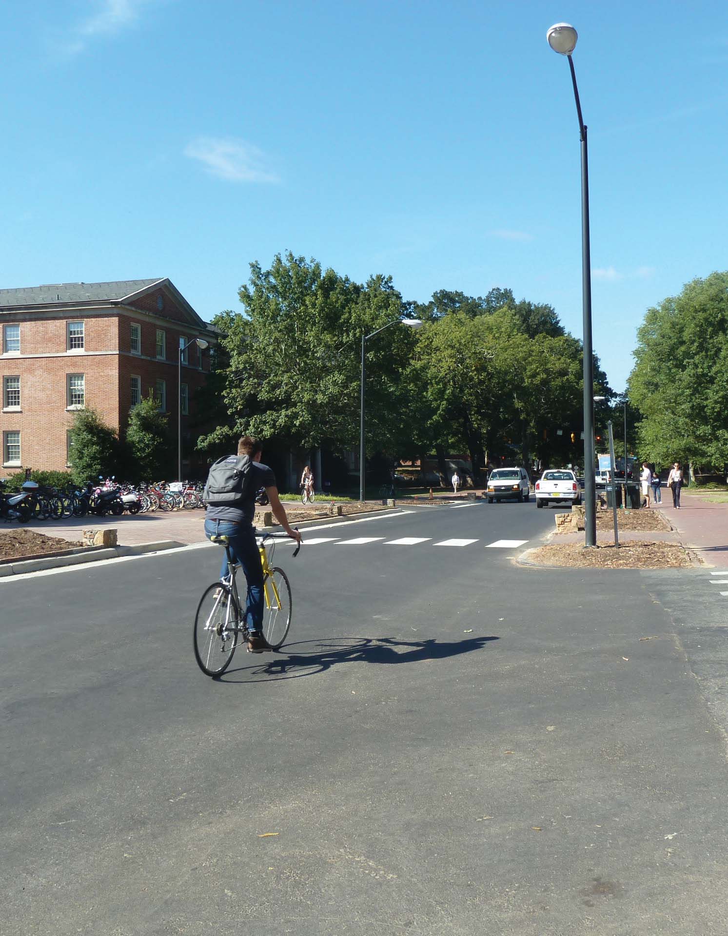
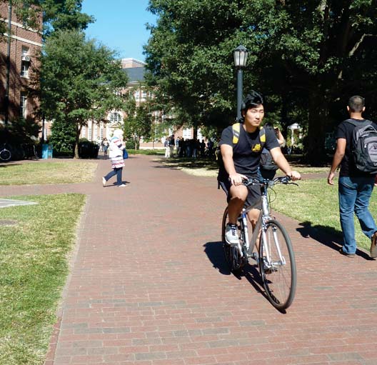
UNC-Chapel Hill undertook this campus bicycle planning effort at a time when interest in bicycling was rising. Many of the campus’ approximately 12,000 employees (not including UNC Hospitals) and nearly 30,000 students already bike to and around campus. Plan input indicates that many more University affiliates would bike more often if additional infrastructure, education or supportive programs existed. The University is poised to strengthen the growing bicycle culture in the Triangle region through improvements to existing bicycle infrastructure and programs at UNC-Chapel Hill.
Mode choice generally has shifted over time with a much higher percentage of both employees and students taking transit today than in 1997. This shift can likely be attributed to the beginning of a fare-free system for Chapel Hill Transit in 2002, and improved and expanded express service and Park & Ride options. This shift also demonstrates that the mode choices of UNC-Chapel Hill commuters do change with improvements to a specific mode. Details of employee and student mode choice are available in Appendix B.
When evaluating the motivations and barriers that influence how people travel to campus, it is again useful to look at the online Bike Plan survey findings discussed in Chapter One.
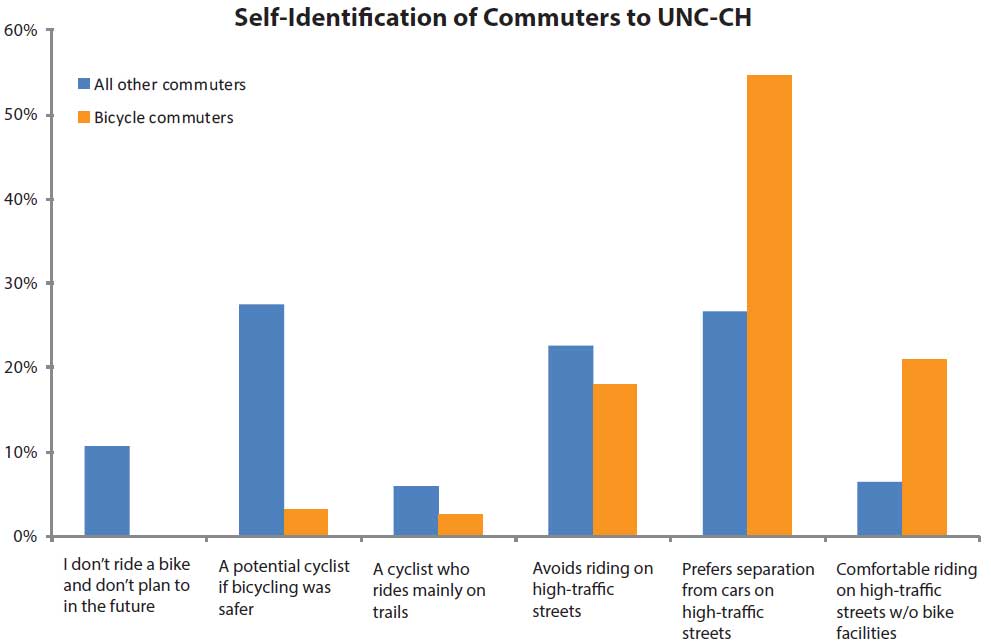
The majority of the cyclists who responded to the Bike Plan survey self-identified as riders who are more confident on the road than an average rider. Respondents were asked to place themselves into a category of cyclist. Figure 5 shows that those who bike to campus are more likely to be comfortable on all types of roads than are those who commute by other modes. These results are not surprising given that most of the roads that access campus are high-volume roads, so those who ride today are already comfortable riding in that environment. There is high potential for attracting additional bicycle riders, as 27.5% of respondents who currently access campus/class by other modes responded that they were a potential cyclist if conditions were safer.
Aside from the question of comfort, distance to campus is the greatest challenge for most potential cyclists. According to the 2013 Campus Commuting Survey, students who bike commute typically live close to campus; 91% of students who travel by that mode live within five miles of campus. The Campus Commuting Survey also found that 63.4% of students and 29.7% of employees who drive alone live within five miles of campus. Five miles is generally considered to be a reasonable distance for a daily bicycle trip, so this group represents a target market for bicycle commuting.
Among employees, a number of Bike Plan survey respondents commented that housing in Chapel Hill is too expensive, causing them to live farther away from campus. Staff who live farther away are less likely to become regular bicycle commuters. However, the 2013 Campus Commuting Survey shows that a higher percentage of University employees live in Chapel Hill and Carrboro (39.3%) compared to any time since 2001. This means that the potential for staff to become bicycle commuters could increase. In its comprehensive plan, the Town has a stated goal of increasing workforce housing, so it is possible that in the future there will be more opportunities for employees to commute by bicycle.
As noted previously, the Campus Commuting Survey considers employees and students who live off campus. Some of the bicycle infrastructure factors that may influence commuters’ decision to bike are outside the jurisdiction of UNC-Chapel Hill and are addressed in the Town Plan. Though non-campus infrastructure is beyond the University’s purview, the bicycling behavior of the UNC-Chapel Hill community could certainly be influenced by new University educational information and programming. On-campus travel, whether by resident students or commuters, will be influenced by University investment in on-campus bicycle infrastructure and programs.
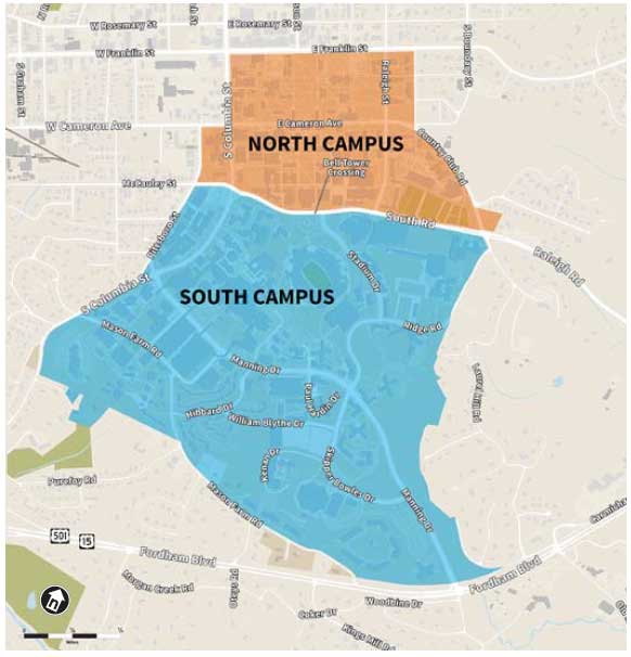
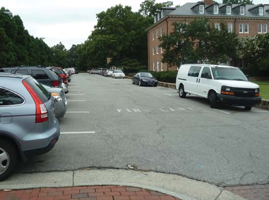
Student, employee and visitor decisions about whether to drive to campus or take other modes are often dictated by the availability of parking. The past decade has brought many changes to the parking environment at UNC-Chapel Hill. Many surface parking lots were removed and replaced with buildings and open space. Parking was consolidated in new decks. Overall, there was a net loss of north campus parking and a net gain of parking on south campus (see Figure 6 for campus region reference).
Current parking availability does not satisfy overall demand. This gap between availability and demand is anticipated to remain and drives the demand for transit, bicycle and pedestrian transportation options.
Parking at UNC-Chapel Hill is governed by the 2013 Traffic and Parking Ordinance, which details locations, permits, fee structures and fines for automobile parking. Off-street parking is available in surface lots and decks on campus for employees, students and visitors. There are also limited, on-street metered spaces for visitors on South Road and Country Club Drive. Parking permits are sold to employees and students on an academic year basis, though freshmen and students residing within a two-mile radius of the Bell Tower cannot purchase a permit. Non-freshmen student residents of UNC-Chapel Hill Housing have parking available in storage lots on campus through a lottery basis.
Annual permits are also sold for UNC-Chapel Hill and Town Park & Ride lots from which students and employees may ride fare-free Chapel Hill Transit buses to campus. Temporary one-day and one-week permits are also available for these lots. Charging for use of Park & Ride lots began in August of 2013.
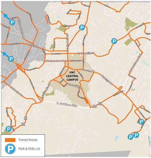
Travelers living farther from campus have the option of combining bicycling with bus trips on Chapel Hill Transit, which serves Chapel Hill and Carrboro, or Triangle Transit, which serves the wider region. Chapel Hill Transit buses are fare-free as they are funded by UNC-Chapel Hill and the Towns of Chapel Hill and Carrboro. Buses attract high ridership, including those UNC-Chapel Hill affiliates mentioned previously who use the Park & Ride lots when bus lines do not extend to the start or end of their trip. Chapel Hill Transit routes and Park & Ride locations are shown on Figure 7.
Chapel Hill Transit and Triangle Transit buses are all equipped with front racks that hold two bicycles. According to anecdotal community feedback gathered, these racks are often full on certain routes during the peak commute. Some Park & Ride lots are also equipped with bicycle racks where riders may lock bikes for storage while they use the transit system.
UNC-Chapel Hill’s main campus features rolling topography typical of the North Carolina Piedmont. The historic core of the campus abuts downtown to the north and is bordered by residential neighborhoods on the east and west. The southern part of campus is separated from neighborhoods farther south by Mason Farm Road and Fordham Boulevard is a four-lane, divided roadway and presents a significant physical barrier to bicycle travel. Major routes into campus, including Raleigh Road, Manning Drive, East Franklin Street and Martin Luther King, Jr. Boulevard, are currently not comfortable for most bicyclists. All of these roads are included in the Town bike plan, and if the recommended improvements are implemented, conditions for bicycling will improve in future years.
Another major route to campus is West Cameron Avenue which has the most heavily used bike lanes in town. The bike lane facilities on West Cameron Avenue make it safer to travel, but significant challenges at the intersections with both Pittsboro Street and South Columbia Street make travel more difficult and less safe. The Town Plan addresses both of these intersections.
On campus, academic undergraduate buildings are concentrated in the northern, historic part of campus mostly north of South Road and stretching west to Pittsboro Street. UNC Hospitals and the medical-related research and academic buildings are located from South Road to the Mason Farm Road area around the west end of Manning Drive. These buildings have the highest number of daily campus visitors. Athletic and recreation facilities are generally in the central and eastern part of campus. These facilities are located south of South Road and extend though the South Campus Recreation Complex and Dean Smith Center area in the southern part of campus off Manning Drive.
Although there are undergraduate residential halls on the historic campus, the majority of students live on south campus. The number of residential halls on south campus has increased over the past ten years, due to the development of Baity Hill, Rams Village, Koury, Hardin, Craige North and Horton Halls along Manning Drive. Due to the distance from these residential areas to the center of campus, the students in these new residence halls represent a large group of potential bicyclists. Residences such as Baity Hill, Rams Village, and Taylor Residence Hall are all farther than a student is likely to walk to class.
While these residences and many other campus destinations may be within a comfortable biking distance from each other, topography creates challenges to bicycle movement throughout campus. The general downslope from north to south on campus is particularly evident when traveling northbound along Stadium Drive, Skipper Bowles Drive, Ridge Road and South Columbia Street. Only South Columbia Street is equipped with bike lanes to provide separation from faster moving automobile traffic. There are also small, steep grade changes on campus in some locations, such as the area between William Blythe Drive and the S-11 parking lot to its south, which create barriers to bicycle travel.
In the Rams Head Center area, a previously steep grade change has been effectively eliminated for bicyclists and pedestrians through the construction of the Rams Head Center. Cyclists and pedestrians now encounter a gradual grade change from the east side of Kenan Stadium to the north side of Morrison Residence Hall. In other areas, pedestrian and bicycle bridges have been proposed in the campus master plan for Manning Drive and South Road to eliminate steep grade changes and also to decrease conflicts between transportation modes. Completion of a bridge crossing Manning Drive between Dental Sciences and Thurston Bowles has improved pedestrian crossing safety across this busy roadway.
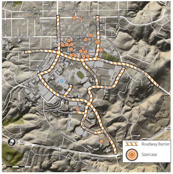
Steep grade changes also have resulted in many stairways on campus that are barriers for bicyclists (see Figure 8 for locations). Many people are not strong enough or comfortable carrying a bicycle on stairs. On campus it is common to suddenly come upon a staircase while biking and need to alter one’s route to reach a destination. For example, traveling south from the main academic area of the historic quads, there is only one pathway (between Wilson Library and the Undergraduate Library) that does not terminate in a staircase at South Road. This effectively funnels all bicycle travel onto this pathway.
Pedestrian safety improvements have been made on most of the roads within and around the campus area in the last decade. Some of these improvements, including raised crosswalks and intersections, were constructed to reduce vehicle speeds in certain parts of campus. These traffic calming measures also benefit bicyclists by bringing automobile speeds closer to those of the bicyclists with whom they share the road.
The speed limit on all campus roads is 25 mph, and this speed limit is enforced by UNC-Chapel Hill DPS officers. Many of the roads that enter campus are high-volume, higher-speed (35 mph) streets. Drivers often appear to come onto campus roads traveling faster than the posted speed. In general, it has been observed that few drivers use the cross-campus streets as through routes, and most vehicles on the roads that cross through campus likely have a destination within campus.
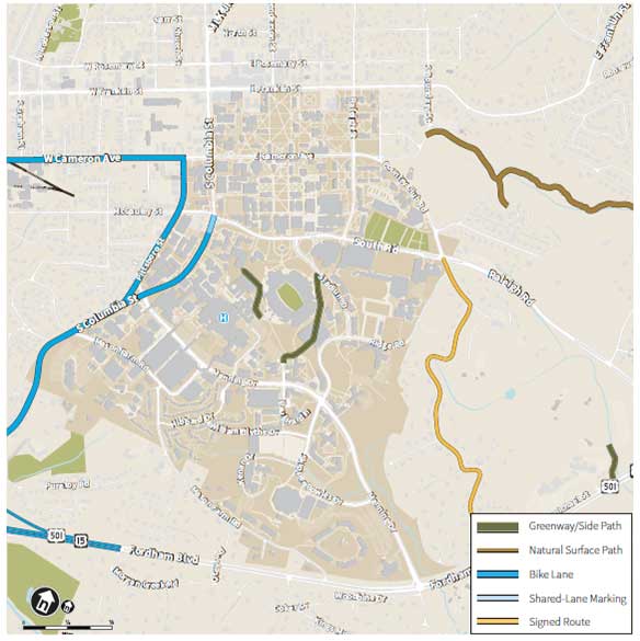
There are few campus streets with bicycle facilities (see Figure 10). Bike lanes exist on both sides of South Columbia Street between Fordham Boulevard and Manning Drive. At Manning Drive, where South Columbia Street becomes one way northbound, a bike lane exists on the east side of the road between Manning Drive and just south of North Medical Drive. This bike lane then transitions to shared lane markings which end at South Road. Additionally, there is a single southbound bike lane on the west side of Pittsboro Street that extends from Cameron Avenue to University Drive.
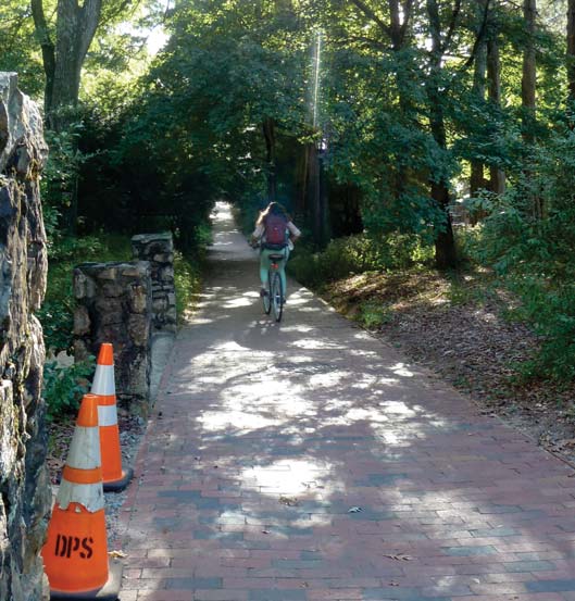
The pathway network was developed to create direct connections for pedestrians between buildings, with the oldest pathways of Polk and McCorkle Places dating back to early in the University’s history. These pathways run parallel to and diagonally between buildings in the historic quads. In many locations the paths are interrupted by short sets of stairs such as those to the Lower Quad located on Raleigh Street.
Pathways range anywhere from five to sixteen feet in width, though the interior quad paths are mostly between six and ten feet wide. Newer pathways such as those over Rams Head Parking Deck and through the Rams Village residences north of William Blythe Drive tend to be on the wider end of the range.
Since these pathways are formalized pedestrian shortcuts, it makes sense that bicyclists with the same destinations would also want to take them. During the academic year and especially during class changes, hundreds of pedestrians and bicyclists share the pathway network, putting it at maximum capacity and creating conflicts between users.
Currently, bicyclists approach this congestion either by biking slowly at the pace of pedestrians or by walking their bicycles. Interactions between bicyclists and pedestrians were generally observed to be courteous, but online feedback from some campus community members pointed out that there are on-going issues with “near-misses” and pedestrian discomfort when bicyclists ride too close or too fast in crowded areas. Additionally, 23.3% of respondents to the bike plan survey who reported that they had been involved in a crash on campus said it involved a pedestrian.
1 Sidewalk riding restrictions are located in Town code Chapter 21, Section 21-3.
The 2001 Campus Master Plan altered the previous bicycle circulation system by placing buildings, parking decks or open green space on surface parking lots. However, there are still many parking lots on campus, and they serve an important connectivity function for bicyclists. For example, Stadium Drive serves a dual function as a road and also a linear parking lot, with perpendicular parking spaces lining both sides of most of the street. Road users must carefully watch for vehicles pulling into or out of the perpendicular parking spaces which line both sides of the road. This roadway is also a bus route and has major pedestrian crossing flows, making travel through the area even more complex.
There are other smaller parking lots that serve as connections such as the lot adjacent to Bynum Hall, the linear lot south of Alumni Hall, linear lots along Emerson Drive and lots associated with most of the south campus residence halls. The complex nature of automobile traffic in all of these lots can lead to unexpected conflicts for drivers and bicyclists that must be a consideration when routing bicyclists through these areas.
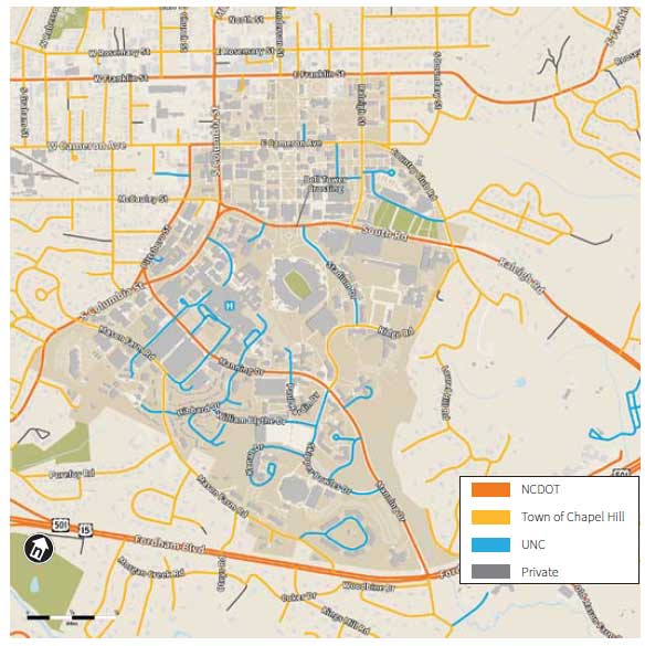
Campus master planning is facilitated through the Facilities Planning Department. In the case of bicycle planning, efforts are currently shared by Facilities Planning and the DPS. These positions will enable DPS to expand its planning capabilities for all modes of campus travel and will oversee the completion of the Development Plan Transportation Impact Analysis on a biennial basis. These analyses are coordinated with Facilities Planning.
DPS is responsible for the Commuter Alternative Program (CAP) which targets employees and commuting students to reduce single-occupancy vehicle trips.
Some student groups are directly involved in promoting bicycling, and there are others whose missions are supportive of bicycling. A full description of campus bicycle programs operated by University staff and student groups is in Chapter 5.
Additionally, there are academic departments and research centers whose work includes bicycle planning. The Department of City and Regional Planning includes some of the premier American academic researchers on active transportation. The Highway Safety Research Center is a nationally respected research group on bicycle and pedestrian issues. Also, research at the School of Public Health and the Sociology Department relates to or addresses bicycling.
There are a number of official University committees whose decisions directly influence the bicycling environment on campus. The Pedestrian and Bicycle Safety Committee is a chancellor-appointed committee consisting of students, faculty and staff, whose purpose is to advise the Chancellor on resolving conflicts among pedestrians, bicyclists and motor vehicles drivers. The group makes recommendations to the campus administration on standards for infrastructure, policies and other matters relating to the safety of these travel modes on campus.
The Chancellor’s Buildings and Grounds Committee is a chancellor-appointed committee consisting of faculty, students and staff that review and approve all changes to the campus physical environment. This includes review of the long-range physical development of the campus, the siting and exterior design of new and renovated buildings, major landscaping changes, the selection of architects and the location of monuments and memorials.
The Advisory Committee on Transportation (ACT) is housed within DPS and oversees all campus transportation matters. Specifically, the ACT is expected to advise on “strategies for convenient, easy to use, and safe transportation access to the campus; and to respond to the changing access needs of faculty, students, staff, patients and visitors to the University and UNC Hospitals on a continuous year-round basis.” This 11-member committee is chaired by the Director of DPS and includes student and staff representatives from departments throughout campus. The committee also provides an annual report and briefing to the Vice Chancellor for Finance and Administration. Historically, this committee has focused mostly on campus transit, parking and fees, though its charge is broad and covers all modes used by the campus community.
Each of the above entities has developed policies or created programs that make up the context for the current bicycle planning effort. No overall structure coordinates the bicycle-related efforts of these groups. It would be helpful to clarify the relationships between these groups and coordinate their work in order to make transportation planning more efficient and effective.
Campus Master Plan
The guiding document for growth and transportation at UNC-Chapel Hill is the 2006 Campus Master Plan Update, which includes planning for car and bus transportation, open space, the pedestrian network and utilities. Bicycle transportation is not explicitly addressed in the 2006 plan and has been incorporated informally into the campus environment in past years.
The Campus Master Plan goals for transportation were originally developed by the 1998 Parking and Transit Task Force for the original 2001 Campus Master Plan. They included the following:
- Encourage a campus and Town environment that is supportive of pedestrians and other alternative modes of transportation.
- Offer affordable, flexible and convenient transportation options that will serve the diverse lifestyles of the campus community.
- Reduce the demand for parking on Main Campus while maintaining an adequate supply for visitors.
- Develop an efficient comprehensive transportation system to better serve the entire University community.
Each of these objectives can be addressed, in part, by increasing bicycling on campus.
The 2001 Campus Master Plan was informed by an ad hoc bicycle advisory group who developed the following campus bicycling mission statement, which is largely reflected in the vision and goals of this Bicycle Master Plan:
To design efficient bicycle transit routes which are safe for bicyclists and pedestrians; to develop adequate bicycle parking facilities, educational programs, and enforcement; to implement policies and incentives to support transportation by bicycle; and to develop architectural guidelines for buildings which include attention to showers and clothing storage for bicycle commuters.
To date, implementation of this mission has not been pursued by the University in a targeted way. However, the completion and incorporation of this Bicycle Master Plan into the Campus Master Plan will take steps toward achieving this mission. This Bicycle Plan will provide the guidance necessary to routinely incorporate bicycle infrastructure into campus planning decisions.
Development Plan/Transportation Impact Analysis
The campus Development Plan, the University’s agreement with the Town as to how it develops the Main Campus, is updated biennially with a Transportation Impact Analysis (TIA). The TIA updates the progress of construction and its impact on transportation to and from campus estimating how traffic will alter as parking availability, destinations on campus, and transportation modes change. The 2013 TIA includes a number of suggestions relating to bicycle infrastructure and programs, with the goal to increase bicycling as a transportation mode. Increasing bicycle transportation will help to mitigate potential increases in automobile traffic as the campus population continues to grow.