
Development Plan Transportation Mitigation Measures and Recommendations
- Columbia Street / South Road / McCauley Street: Improvements at this intersection are complete. The improvements included remodeling to improve pedestrian safety, as well as an exclusive left-turn lane on the McCauley Street approach that was accomplished through pavement marking changes without widening the road.
- South Road / Country Club Road: Improvements have already been made here without widening the road. A northbound right-turn lane has been added, and the southbound shared through-right lane has been converted to a shared left-through-right lane. In addition, realignment of the Ridge Road / County Club Road intersection, to give priority to Ridge Road, has been recommended as a long term option.
- Cameron Avenue / Raleigh Street: Signal phasing changes have been implemented to improve traffic flow. As discussed earlier, the Town has indicated the possibility of revisiting this intersection and considering the implementation of an exclusive westbound right-turn lane on Country Club Road.
- Country Club Road / Battle Lane / Boundary Street: Bollards and chains have been strategically provided to control pedestrians in and around this intersection, and a stamped asphalt pedestrian crossing was installed. If the Town and University determine that other improvements are necessary, the University will coordinate with the Town to design and implement the agreed upon improvements.
- Country Club Road / Gimghoul Road / Paul Green Theater Drive: A traffic signal including pedestrian countdown heads has been provided.
- Manning Drive / Skipper Bowles Drive: Based on peak period counts and the accident history at this location, turn restrictions have been implemented to prevent eastbound left-turns from Skipper Bowles Drive onto northbound Manning Drive during special events. Recent changes in the parking allocation of the Development Plan indicated the potential for an increase in the number of parking spaces accessible via Skipper Bowles Drive. It was noted in past Annual Reports that the University would collect additional traffic volume data at this intersection to perform a more thorough analysis to determine if applicable warrants for the installation of a traffic signal are met. The proposed changes to the parking allocation, while still included in the Development Plan, have not been constructed. Signal warrants were performed for this intersection in the TIA update and the intersection does not meet the warrants for installation of a traffic signal.
- South Columbia Street, between Manning Drive and South Road: The cross-section of this portion of South Columbia Street has been altered as stipulated to remove a vehicular travel lane and to add an exclusive bike lane and an exclusive bus lane. Construction of the accompanying streetscape features are complete as well. A new pedestrian activated traffic signal at the intersection of South Columbia Street and Medical Drive was also constructed as part of the streetscaping project.
- Manning Drive / Fordham Boulevard: Stipulated improvements for this intersection have been completed. The University provided funding for the stipulated street lighting. The University also prepared traffic signal upgrade plans in coordination with the Town and NCDOT for the stipulated traffic signal upgrades at this intersection to improve pedestrian safety. The Town of Chapel Hill utilized contractor services to complete the intersection upgrades.
- Fordham Boulevard / Old Mason Farm Road: Stipulated improvements for this intersection have been completed. The University has provided funding for the stipulated street lighting. The University also prepared traffic signal upgrade plans in coordination with the Town and NCDOT for the stipulated traffic signal upgrades at this intersection to improve pedestrian safety. The improvements to the traffic signal have been completed.
- Mason Farm Road / East Drive: A stipulated traffic signal for this intersection has been constructed. The University prepared the necessary traffic signal plans and provided those plans to the Town of Chapel Hill. The Town utilized contractor services to construct the new traffic signal.
- Mason Farm Road / West Drive: A new traffic signal was stipulated at this intersection. The University designed and implemented a temporary traffic signal to operate at this intersection until construction of Marsico Hall was completed. The construction of Marsico Hall is completed and the final signal featuring metal poles with mast arms is to be constructed in early 2016.
- Ridge Road: Resurfacing has been stipulated along the length of the road. Other safety improvements have already been made near the Rams Head Center and other pedestrian safety enhancements have been constructed adjacent to Boshamer Stadium and were completed in 2010. The University is performing a study of potential improvements to pedestrian and bicycle facilities on Ridge Road.
- Manning Drive / Ridge Road: Although traffic delays are not an egregious problem here, there are speed and appearance issues. Measures to reduce and calm traffic and to enhance pedestrian safety should be studied. Measures to encourage pedestrians to cross at the intersection have been implemented.
As expected, the proportion of both employees and students driving alone has fallen further since 2001, with a reverse trend since 2015. Similarly, the park-and-ride use has increased since 2001, however has been dropping since 2013 (likely due to pricing changes for using park-and-ride lots). This general decrease in employees and students driving alone is because:
- construction to date has resulted in a net loss of over 1,000 employee spaces,
- the employee and student populations have increased, and
- the University has invested heavily in improvements to alternative modes.
Chapel Hill Transit (CHT) and GoTriangle have been particularly popular. This is a successful result of investment in fare-free transit, subsidized GoPasses and other service enhancements.
It appears that some employees living in Chapel Hill and Carrboro are choosing to drive to a park-and-ride lot rather than walk to a local CHT stop, in order to take advantage of the more frequent transit service. This may not be as big a problem as in the past because of the new park-and-ride fees which have reduced use at park-and-ride lots. Also, geocoding data suggest that University employees are living further away from campus than in previous years, increasing the value of park-and-ride compared to CHT.
| Mode | Employees | ||||||||
|---|---|---|---|---|---|---|---|---|---|
| 2001 Ratio | 2004 Ratio | 2007 Ratio | 2009 Ratio | 2011 Ratio | 2013 Ratio | 2015 Ratio | 2017 Ratio | New Projections | |
| Drive alone | 0.72 | 0.61 | 0.56 | 0.49 | 0.57 | 0.51 | 0.61 | 0.64 | 0.45 |
| Carpool/vanpool | 0.06 | 0.05 | 0.06 | 0.07 | 0.05 | 0.05 | 0.05 | 0.05 | 0.08 |
| Bus | 0.06 | 0.08 | 0.10 | 0.13 | 0.10 | 0.15 | 0.16 | 0.15 | 0.26 |
| Bicycle | 0.03 | 0.02 | 0.03 | 0.04 | 0.02 | 0.04 | 0.05 | 0.04 | 0.03 |
| Walk | 0.02 | 0.02 | 0.03 | 0.03 | 0.02 | 0.03 | 0.01 | 0.02 | 0.02 |
| Park-and-ride | 0.07 | 0.15 | 0.16 | 0.17 | 0.18 | 0.16 | 0.07 | 0.05 | 0.11 |
| Other | 0.04 | 0.06 | 0.07 | 0.07 | 0.05 | 0.07 | 0.05 | 0.04 | 0.04 |
| Mode | Commuting Students | ||||||||
|---|---|---|---|---|---|---|---|---|---|
| 2001 Ratio | 2004 Ratio | 2007 Ratio | 2009 Ratio | 2011 Ratio | 2013 Ratio | 2015 Ratio | 2017 Ratio | New Projections | |
| Drive alone | 0.33 | 0.19 | 0.18 | 0.17 | 0.14 | 0.16 | 0.18 | 0.25 | 0.16 |
| Carpool/vanpool | 0.08 | 0.07 | 0.08 | 0.03 | 0.04 | 0.04 | 0.03 | 0.02 | 0.08 |
| Bus | 0.21 | 0.34 | 0.35 | 0.39 | 0.42 | 0.37 | 0.51 | 0.39 | 0.41 |
| Bicycle | 0.09 | 0.05 | 0.06 | 0.11 | 0.10 | 0.08 | 0.13 | 0.13 | 0.08 |
| Walk | 0.12 | 0.14 | 0.14 | 0.12 | 0.11 | 0.15 | 0.05 | 0.09 | 0.11 |
| Park-and-ride | 0.12 | 0.16 | 0.10 | 0.14 | 0.15 | 0.12 | 0.06 | 0.06 | 0.10 |
| Other | 0.06 | 0.06 | 0.09 | 0.05 | 0.08 | 0.04 | 0.06 | 0.06 | 0.06 |
Notes
- “Carpool/vanpool” includes drivers and passengers.
- “Bus” includes Chapel Hill Transit and Regional Transit.
- “Other” includes motorcycles, dropped off, work from home, etc.
- Existing ratios are based on Tuesday data from the Commuter Survey
- NOx: 18 kg/day (5,259 kg/year)
- VOC: 32 kg/day (7,785 kg/year)
- CO: 583 kg/day (151,653 kg/year)
Methodology and data analyzed for estimating air quality impacts are explained in more detail in Section 3.5 of the December 2017 Development Plan TIA report.
Figure 3.1: Traffic Calming and Pedestrian Improvements On Campus
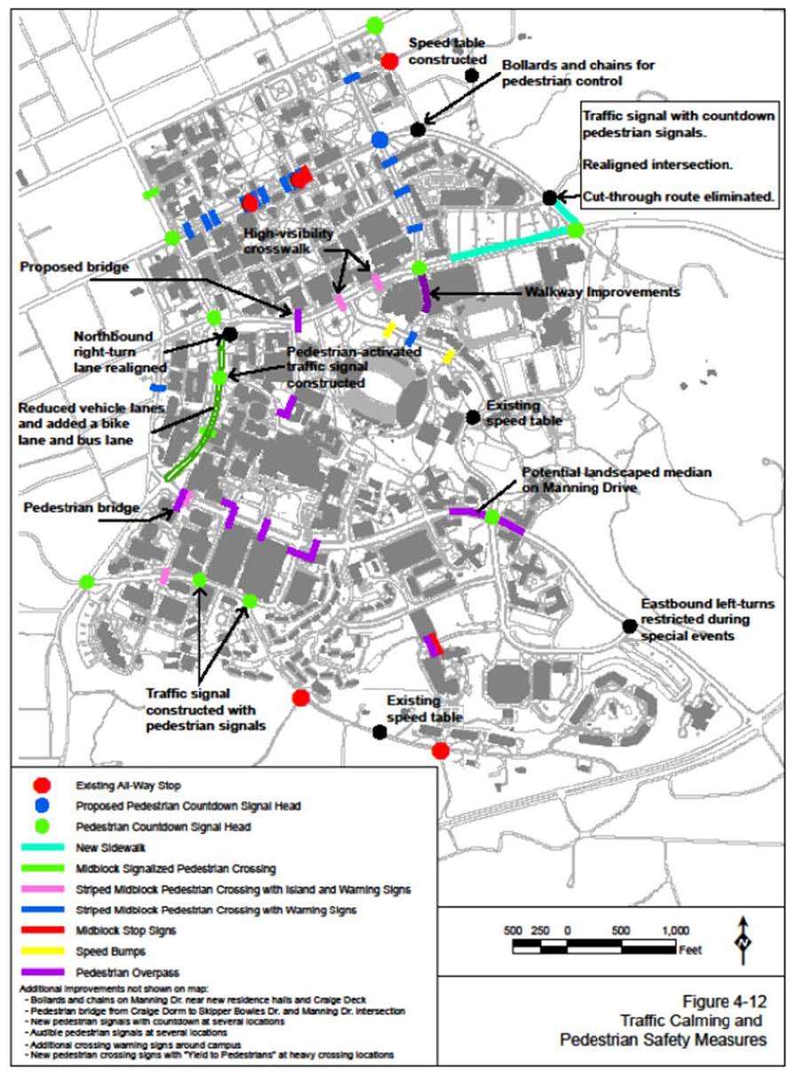
Table 3.2 shows the streets that were considered for possible impacts and potential mitigation measures. The measures that were agreed upon have all been implemented as indicated in Table 3.2. The measures were designed and implemented at no cost to the Town. The Town will maintain the traffic calming devices on Town streets.
In 2011 Town staff indicated some neighborhood residents had applied to the Town to consider additional traffic calming to be implemented. The University gathered daily traffic volume and vehicle speed data at three locations on streets where traffic calming measures had been constructed. The data was provided to the Town staff for use in their assessment of the resident’s application. To date, the Town of Chapel Hill has not taken action to modify the traffic calming measures that were designed and constructed by the University.
| Street | Identified for Implementation? | Traffic Calming Measures Status |
|---|---|---|
| Westwood Drive, Ransom Street, McCauley Street, and Vance Street | No. Traffic calming measures have already been implemented. | Complete |
| Oteys Road | No. Traffic calming measures have already been implemented. | Complete |
| Purefoy Road | No. Traffic calming measures have already been implemented. | Complete |
| Mason Farm Road | No. Traffic calming measures have already been implemented. | N/A |
| Ridge Road | No. Traffic calming measures have already been implemented. | N/A |
| Laurel Hill Road | No. Alignment and cross-section of road is already a calming measure prohibiting high travel speeds and creating longer travel times than competing routes. | N/A |
| Gimghoul Road | No. Church property was sold and will be redeveloped as residential units. As a result, the cut-through route connecting to South Road (NC 54) was eliminated. The intersection of Gimghoul Road and Country Club Road has been signalized. Paul Green Theater Drive was relocated to align with Gimghoul Road. | Complete |
| Raleigh Street | No. Traffic calming measures have already been implemented. | N/A |
| Cameron Avenue | No. Traffic calming measures have already been implemented. | N/A |
| Battle Lane | No. Traffic calming measures have already been implemented. | N/A |
| Boundary Street | Yes. Plans were completed and submitted to Town for implementation. | Complete |
| Park Place | No. Traffic calming devices were deemed not feasible on this street. | N/A |