Chapter 1: Plan Process
Support for the creation of a Plan was built over several years and came from a variety of groups. An environmental studies class project proposed a bicycle plan in 2001. The Campus Pedestrian Safety Committee added bicycle safety to its charge in 2009 and began to outline the requirements of a bicycle plan. Momentum for this plan grew in 2012 when the Carolina Bicycle Coalition, a student advocacy group, was formed, and a student-run pilot bike share program, Tar Heel Bikes, was launched. The development of this Plan was managed by the Facilities Planning Department in partnership with the Department of Public Safety (DPS). Planning process details are provided in Appendix A.
- Bicycles are recognized as a valued mode of transportation and receive an equal priority in planning and funding on campus.
- Bicycling is a mode that is available to all types of riders in a safe, comfortable and visible network.
- Bicycling is institutionalized and integrated into the culture of the University.
- All road users are educated about bicycling, including drivers, pedestrians and cyclists.
- Conflicts between bicyclists and other modes are reduced.
- On-road infrastructure is improved for bicyclists.
- Non-road facilities are used to create improved connections.
- Connections and routes are widely known and easy to find.
- Town-University bicycle connections are easy.
- Supporting infrastructure for bicyclists is created.
- Supporting programs for bicyclists are created.
Challenges to success were also identified and include:
- Many students come from parts of the state and country where bicycling is not part of the way of life.
- There is currently no money specifically allocated for physical bicycle improvements on campus.
- The topography of campus, especially north-south, poses a physical barrier for bicycling.
The first two challenges are addressed in this plan. The last issue, topography, will continue to be a challenge, but recommendations to mitigate the topographical challenges are included.
- Staff from the DPS
- University administrators from Athletics, Campus Recreation, Parking, Facilities Planning, Real Estate and UNC Healthcare.
- Campus Pedestrian and Bicycle Safety Committee (PBSC)
Survey respondents provided valuable feedback that informed the development of Plan recommendations for both physical infrastructure, policies and programs. Overarching results are presented here, and additional survey information is included throughout the Plan to describe existing conditions and support recommendations.
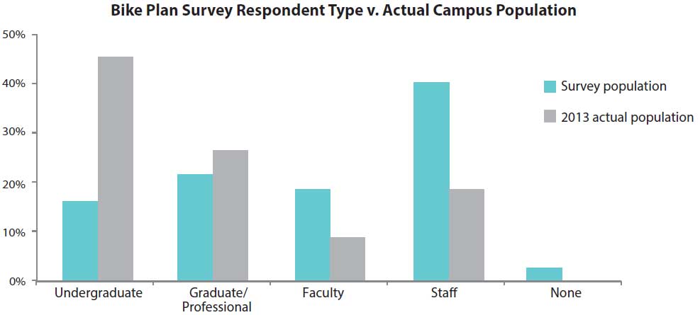
Although the survey results were important to the planning process, it is important to note that the survey sample was not representative of the campus population in two aspects: affiliation and typical commute mode. Figure 1 shows that staff were heavily over-represented in the Plan survey sample. This was likely because the survey was held during summer months while faculty and students were away from campus.1 Over-representation of bicyclists is common for a bike plan survey because of significant outreach to bicycling communities during the planning process, and because they are more likely to have experience, input and interest in issues related to biking.
About 60% of survey respondents have biked on the UNC-CH campus within the past year. Those who have not biked on campus most often responded that they were deterred by high-stress roads they would need to ride or cross to access campus and that they are not comfortable sharing the roadway with automobile traffic. It is likely that many of these comments pertain to roads outside of the UNC-CH campus, which are addressed in the Town Bike Plan, but some are located on campus. Infrastructure and education recommendations in this Plan address both safety issues and the perceived fear or discomfort that non-riders feel.
| Factor | Percentage Answered |
|---|---|
| There are too many high-stress roads I would need to ride. | 59.9% |
| I don’t feel safe riding a bicycle on roads with cars. | 45.9% |
| There are too many high-stress roads I would need to cross. | 34.4% |
| I don’t own a bicycle. | 28.1% |
| It’s too hilly. | 22.4% |
| Other | 21.5% |
| There are too many barriers to biking (freeways, stream valleys, lack of street connectivity). | 19.8% |
| It would take me too long to bike to the places I need to go. | 19.5% |
| I own a bicycle but it’s not in good riding condition. | 8.0% |
| Family travel needs. | 7.7% |
| There is insufficient bicycle parking at my destination. | 7.2% |
| I am physically limited from riding a bicycle. | 5.2% |
Respondents were also queried about what programs and amenities could influence them to bike more often to or around campus.
| Factor | Percentage Answered |
|---|---|
| Education for motorists on how to respectfully share the road | 44.2% |
| Showers and lockers at work | 39.2% |
| Better bicycle parking/storage | 36.3% |
| Improved maintenance (street sweeping/repair of roads) | 30.9% |
| Increased enforcement of traffic laws | 28.0% |
| Other (please specify) | 26.1% |
| Directional signage for bikes | 23.0% |
| Education for yourself on how to ride with motor vehicle traffic | 18.8% |
| More availability of on-bus bike racks | 17.8% |
| A larger bike sharing program | 16.1% |
| Ability to buy daily parking permits | 11.7% |
Among the 26% of respondents who chose “Other” on the previous question, infrastructure improvements such as bike lanes were the most popular fill-in answer. The question was specifically designed to ask about non-infrastructure improvements, but this pattern of responses speaks to the desire among those surveyed for more on-road bicycle facilities.2
Another survey question addressed preferences for bicycle facility types among survey respondents. When asked directly about what infrastructure would encourage them to bike more often, respondents strongly preferred dedicated bicycle facilities (sidepath, sidepath with separation from pedestrians, bike lane) to shared facilities (shared lane marking, wide outside lane).
| Factor | Percentage Answered |
|---|---|
| Sidepath | 60.7% |
| Sidepath with designated space | 59.7% |
| Bike lane | 59.3% |
| Shared lane marking | 13.8% |
| Wide outside lane | 14.3% |
1 The survey remained open one week after students and faculty returned. But respondents still heavily represented staff members.
2 An overview of bicycle facility types is provided for reference in Appendix C.
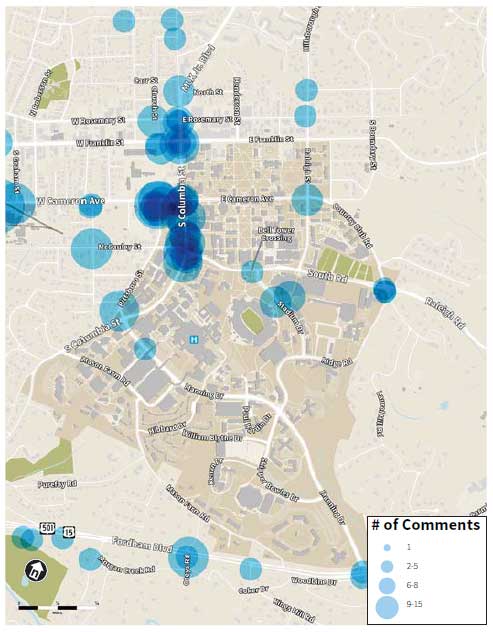
The same map tool was available for use by both the UNC-CH and Town planning processes, but 72% of users of the map were UNC-CH affiliates, with the largest user group being staff. Many routes and places identified on the map were either on UNC-CH’s campus or lead to it, which is not surprising since UNC-CH is a primary destination within the Town.
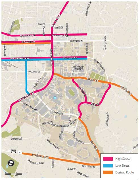
Routes through campus were marked as high- and low-stress. The high-stress routes tended to be on-road. Generally, comments about high-stress roads focused on the speed of traffic and conflicts with vehicles rather than pedestrians.
The most frequently marked high-stress road was the single block of South Columbia Street from South Road to Cameron Avenue. WikiMap users noted that separated, dedicated space for bicyclists would be desirable in this area, since there is no space for bikes on the road and many pedestrians on the sidewalk. The intersection at South Road and South Columbia Street was also frequently noted as a problem with confusing turning and crossing movements for bicyclists, pedestrians and drivers.
“Buses don’t fit in the very narrow lane much less cars. Sidewalk is wide but pedestrian heavy. Unclear if bikes should share the road or share the sidewalk as both are unsafe.”
– WikiMap comment on South Columbia Street between South Road and Cameron Avenue
As shown in Figures 2 and 3, roads marked as high-stress tended to also be the location of identified problem intersections.
Manning Drive was also called out as a high-stress road, with comments about the route focusing on the eastern end that accesses Fordham Boulevard. One commenter noted that drivers tend to be impatient when traveling behind bikers riding uphill, causing many bikers to use the sidewalk in the uphill direction. Portions of the sidewalks along this segment are in poor condition. Ridge Road, Stadium Drive and the east end of South Road were also all identified as high-stress roads.
“Disaster area. One of the two worst intersections near campus for bicyclists. Not enough room for cars and bikes. No bike lane, no bike path, no bike share the road markings. Fix please.”
– WikiMap comment on intersection of South Columbia Street and South Road
Many routes on campus were marked as low-stress for bicyclists, including both on-road routes and off-road pathways. Cameron Avenue was rated as the least stressful on-campus road. There were no off-road routes identified as stressful. Some users identified off-road to on-road transitions as uncomfortable due to narrow pathways.
Data was also gathered on this WikiMap about bicycle parking needs. This topic will be addressed in Chapter 4.
An open house to present draft recommendations for the physical infrastructure network, programs and policies was held on October 23, 2013 at the Student Union. Approximately 80 students, faculty and staff attended to give feedback on the draft plan. Participants marked up paper maps and voted on facility options. Voting was also conducted on:
- Bicycle program recommendations
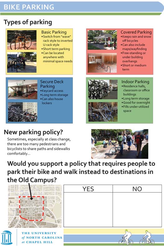
- A suggested policy to restrict bicycles in the core of old campus (bounded by Franklin Street, South Columbia Street, South Road and Raleigh Street)
- Options for funding infrastructure and programs