
As discussed in Chapter 2, there are a number of challenges for bicyclists traveling to and through campus. This chapter provides an overview of the proposed UNC-CH bicycle network. The proposed UNC-CH bicycle network will consist of a series of easily identifiable primary and secondary bicycle routes that are seamlessly connected to the Town bicycle network. The routes are intended to be designated on maps and with wayfinding signs.

Each route follows various combinations of individual roadway, pathway and parking lot segments that presently exist or are proposed as future projects. To promote safety and use of these routes, this plan recommends physical changes to portions of each route to mitigate common challenges bicyclists experience where appropriate. Improvements are categorized as short term or long-term depending upon the degree of complexity and potential construction cost. For many long-term recommendations, there are multiple options which will require further evaluation before a preferred option is selected. Appendix C defines the engineering treatments proposed to improve the routes and provides reference to applicable design guidelines and standards governing the installation and operation of those treatments. Appendix D provides detailed descriptions of the existing conditions, short- and long-term recommendations, implementation challenges and improvement costs for individual segments which comprise each bicycle route.

This Plan was developed concurrently with the Town of Chapel Hill Bicycle Master Plan, and the bicycle facility recommendations are coordinated between the two plans. The improvements described within this chapter are limited to those improvements which are within the boundaries or immediately adjacent to the UNC-CH campus. Streets outside the boundaries of UNC-CH, while critical to support bicycle trips to and through campus, are discussed within the Town Plan. Discussion of those improvements is not included in this plan. Combined, the two plans will result in the development of a robust bicycle network that is connected, convenient and safe, serving bicyclists as they move within and through the campus, as well as to and from campus from points around town.

Implementation of this plan will require cooperation and coordination between the University, the Town and NCDOT. Many of the streets and proposed routes within the UNC-CH campus are primarily maintained by the Town or NCDOT, thus changes to those streets will require their support. Additional flexibility may be available for recommendations which may require relocation of curbs or reconstruction of sidewalks where the adjacent property is owned by UNC-CH, but there are instances where the property is privately held or owned by either the Town or NCDOT. Within Campus, UNC-CH has sole authority to implement changes proposed on Stadium Drive, Hibbard Drive, William Blythe Drive, Kenan Drive, and Skipper Bowles Drive. Strategies necessary to implement and fund these projects are included in Chapter 6.

This plan proposes a series of bicycle routes to service internal and external trips to and through the UNC-CH campus. These routes will be identified with wayfinding signs at key intersections and decision points as well as denoted on campus maps. Initially these routes would utilize existing infrastructure such as streets, campus parking lots and shared use paths. To improve bicyclist safety and comfort, physical changes are recommended on individual segments of these routes ranging from the placement of pavement markings such as sharrows or complete reconstruction of a street to install a shared use path or bicycle lane. The timing of the improvements from near term to long term depends on the type of improvement and the ownership of the route segment. Prior to the identification and development of bicycle routes, an assessment of existing bicycle circulation through and within North Campus was required, including the assessment of a potential dismount zone.
Within North Campus the close proximity of academic buildings results in high volumes of pedestrians and bicyclists throughout the day on the existing sidewalks and pathways. During class change periods, a majority of the sidewalks are operating near capacity with limited freedom to maneuver on the sidewalk. However, unlike South Campus, the dense network of sidewalks creates multiple routing alternatives for bicyclists and pedestrians, alleviating some of the tensions that might otherwise arise from crowded conditions. Options studied for North Campus included application of a dismount zone or identification of a primary bicycle route through North Campus.

To manage conflicts between pedestrians and bicyclists, other universities have implemented bicycle dismount zones with varying degrees of success for all or part of the day. Examples include:

Universities with Bicycle Dismount Zones
Institution Hours of Restriction Location Enforcement
University of Washington 24 hours Core $25 ticket
University of California – Berkeley 8 a.m.-6 p.m. Select crossings Citation
University of Oregon 24 hours Core $30 ticket

Based on discussions with staff and observations of dismount zones at universities with this policy, the effectiveness of a bicycle dismount zone (or walk zone) varies from campus to campus based on a number of factors including: enforcement, size of zone, availability and proximity of alternative routes, bicycle parking, security and time of day. Last and not least, the overall campus culture plays a major role. Feedback through the UNC-CH bike plan public process indicates there is concern with conflicts between pedestrians and bicyclists on north campus, but there is not support from the biking community for a mandatory dismount zone.

Dismount Zone Recommendations

It is not recommended the University implement a dismount zone in the short term. It is recommended the University undertake the following three actions:

  1. Provide additional bicycle parking around the perimeter of North Campus (see Chapter 4).
  2. Track pedestrian/bicycle conflicts within North Campus.
  3. Implement education and enforcement strategies to change behavior (see Chapter 5).

If after these recommendations are implemented and pedestrian/bicycle conflicts are documented to occur on a regular basis, it may be necessary to reconsider the dismount zone. If pursued, limit the dismount zone to the area where safety issues persist during peak periods of pedestrian activity.

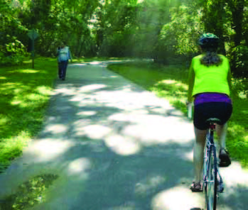
The development of the primary and secondary bicycle route network is based on the recommendation to not pursue a dismount zone. Additionally, given the density of sidewalk and alley options on North Campus combined with the diverse origins and destinations of bicyclists, bicycle routes will not be designated or signed within the boundaries of North Campus. Bicyclists will enjoy full access to all of the sidewalks, parking lots and streets within North Campus.

The primary routes are intended to connect key external destinations as directly as possible (see Figure 11). Routes located outside of campus are recommended by the Town and will be implemented by the Town. Within campus, there are four primary north-south routes proposed to connect South Campus to North Campus that are viable given the existing terrain and street/pathway connectivity challenges. Two additional routes are proposed by the Town to facilitate connectivity between major off campus student housing complexes and North Campus. Between South Columbia Street and Raleigh Street, South Road is a large barrier to bicyclists traveling north-south due to a significant grade change. There is only one path which does not require bicyclists to dismount to navigate stairs: the Bell Tower crossing. This plan recommends additional options to cross South Road to increase connectivity between North Campus and South Campus. The retrofit of staircases with bicycle rails and future replacement of the staircases with bridges to enhance connectivity are also discussed later in this chapter.
There are large numbers of students, faculty, visitors and staff who originate off-campus and desire bicycle-friendly routes to the UNC-Chapel Hill and UNC Hospitals. Some of these key external destinations which generate bicycle traffic to and from campus include the Glen Lennox Apartments and Meadowmont communities to the east, Bicycle Apartments to the north, Town of Carrboro to the west and Southern Village to the south. The Town Plan recommends development of signed bicycle routes between these connections and UNC-CH as well as short- and long-term physical improvements along these routes. The Town Plan routes and connections to UNC-CH are illustrated on the proposed bicycle routes map and identified as primary routes (see Figure 11).
Within campus, a primary function of the bicycle network is to provide north-south connectivity for students residing on South Campus who need to travel to North Campus classrooms and recreation destinations. The UNC-CH campus houses significant numbers of students in the southeast (residential/athletics) portion of campus who desire bicycle-friendly routes to North Campus (academic campus) and into Town. Residence halls are also located within the southwest (medical campus) portion of campus. Future campus redevelopment is envisioned in the southwest quadrant of campus which may add additional classrooms and residence halls. Connections to these key destinations are illustrated on the proposed bicycle routes map and identified as a combination of primary and secondary routes.
Primary and Secondary Bicycle Routes
Figure 11. Proposed North-South and East-West Bicycle Routes
In the short term, improvements are generally limited to those that are achievable with fairly low costs. This is achieved by limiting recommendations to those that can be implemented within the existing street cross section to avoid major street reconstruction. Within the campus sidewalk system, the improvements are limited to staircase modifications and curb ramp improvements. The locations for the improvements described below are depicted on the short term map (see Figure 12) and in Appendix D with additional detail.
Wayfinding sign
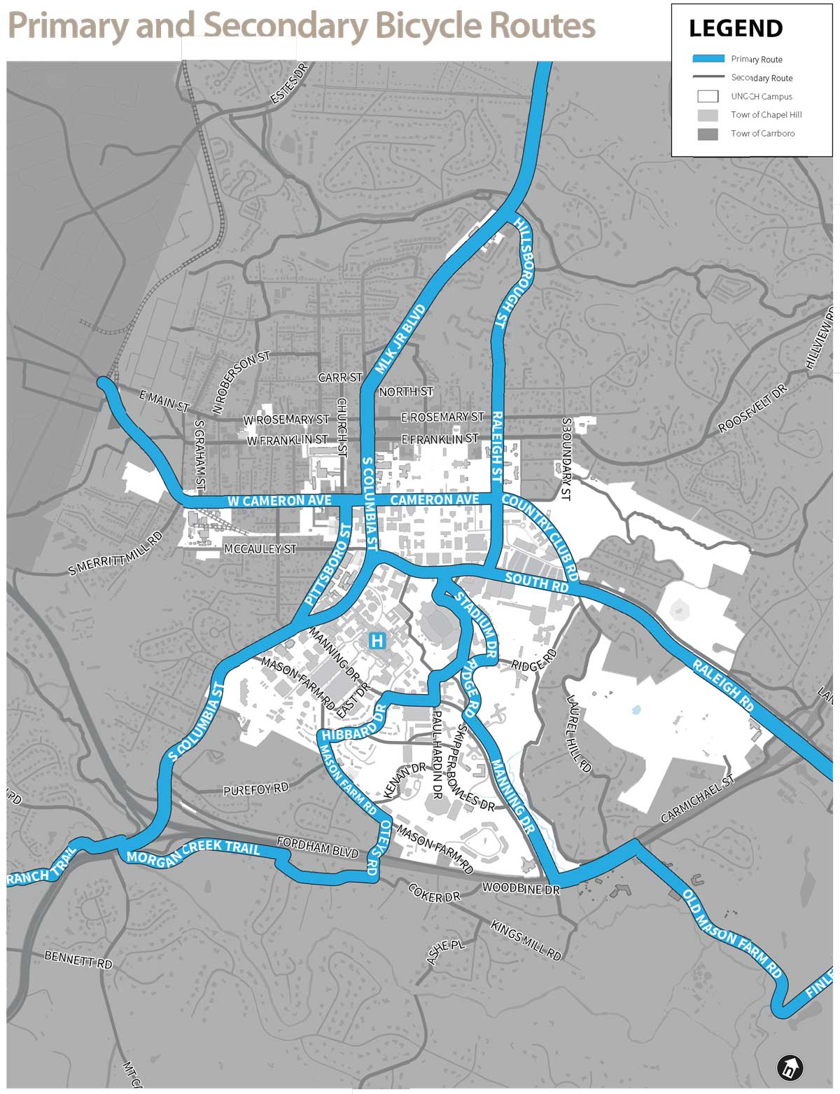
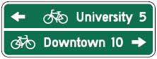
It is recommended wayfinding signs be installed on all primary and secondary routes. The design and installation of the wayfinding signs should be coordinated with the Town to ensure a uniform approach is developed to guide sign design and installation across jurisdictional boundaries. To simplify coordination, the use of a combination of MUTCD 1 D1 and D11 series signs is recommended. Customized graphics could be developed for use on the D11 sign. At a minimum, the signs should provide destination information with confirmation arrows. Supplemental signs directing bicyclists to locations with bicycle parking can be valuable where the parking is not readily visible such as in parking decks. M1 series signs may supplement the D series signs to identify the United States Bicycle Route 1 route which traverses Cameron Avenue and Country Club Road.


1 The Manual on Uniform Traffic Control Devices (MUTCD) is the national standard for roadway and pathway signage and markings.

In the short term, it is recommended that a combination of bicycle lanes, climbing lanes and marked shared lanes be added to the existing roadway network.

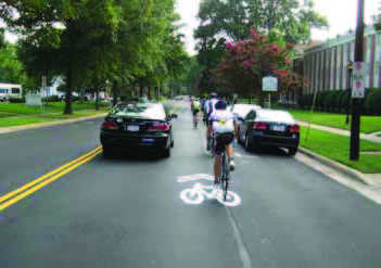
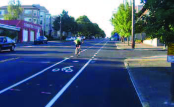
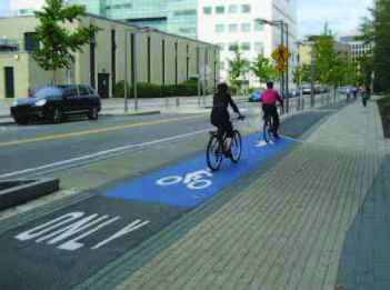
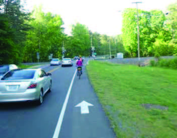
The improvement used will be determined mostly by the existing road width. Bicycle lanes, which create a separate space for the bicyclists to travel on both sides of a roadway are preferred. However, where there is not room for separate bike lanes in both directions and there are steep slopes, a climbing lane is recommended. The climbing lane is a separate bike lane only on the uphill side of a roadway. This separated lane allows bicycles to travel safely uphill without impeding vehicular traffic lanes. Where there is no room for either bike lanes, or a climbing lane, marked shared lanes can be used. The marking of the lane as a shared use lane consists of a symbol placed in the center of the lane to indicate that this roadway is a shared use facility for both vehicles and bicycles. The symbol is repeated at regular intervals. The shared lane markings primarily are used as a tool to raise awareness that both bicycles and vehicles should share the road.

Shared Lane Marking
Shared Lane Marking
Climbing Lane
Climbing Lane
There are numerous staircases throughout the path and sidewalk network on the UNC-CH campus. At staircases, bicyclists must dismount and carry their bicycles up or down the stairs. This can be a serious impediment for some bicyclists, especially if the bicycle is carrying loaded bags. Stairs inconvenience or limit route options for bicyclists within the campus. To improve bicyclist circulation throughout campus, it is recommended five staircases be retrofitted with bicycle channels to allow bicyclists to more easily navigate staircases. The bicycle channel is typically a V-shaped or U-shaped channel that runs parallel to the stairs and it is designed to allow bicycle wheels to roll up or down the staircase. The channel should be mounted close to the stair and the design of the channel should allow the bicycle to navigate the staircase without catching a handlebar on a wall or railing. Five locations are proposed:

  1. West side of Graham Student Union
  2. East side of Caudill Labs
  3. East Side of Kenan Labs
  4. North side of Kenan Stadium
  5. Baity Hill Student Family Housing
Student Union Staircase
The staircase between the Student Union and UNC Student Stores is a major barrier to north-south travel on campus and is a high priority for retrofit with a stair channel.
Stair Channel
This stair channel includes a non-slip surface and instructional signage to aid bicyclists.
Campus Health Staircase
The staircase adjacent to Campus Health has an existing gravel path that bicyclists use. A bicycle ramp could replace the gravel path.

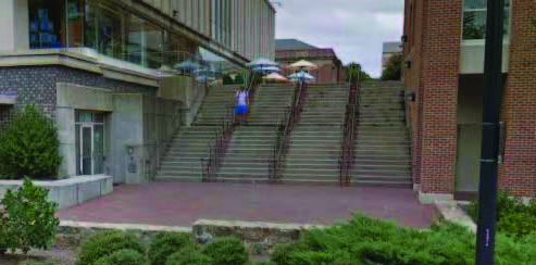
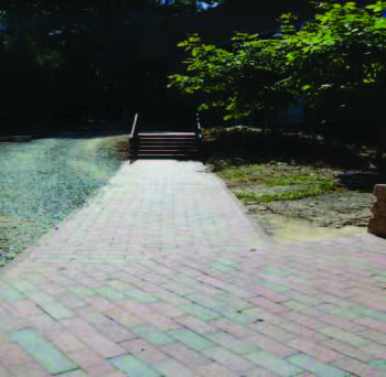
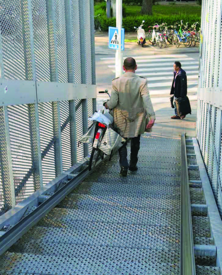
There are three additional locations where relatively short staircases impede bicycle travel through campus on priority bicycle routes. It is recommended these staircases be replaced with American with Disabilities Act (ADA)-compliant accessible ramps. The location of these ramps are at key transitions between the campus and the staircases at the following locations:

  1. Staircase approaching the eastern eastern Franklin Street crosswalk at Henderson Street from McCorkle Place
  2. Staircase connecting Fraternity Court to University Square
  3. Staircase adjacent to Campus Health Services.

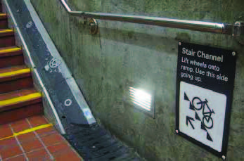
In the event it is determined that the staircases cannot be replaced with ADA-accessible ramps, consideration should be given to constructing bicycle ramps adjacent to the existing staircases. A bicycle ramp creates a barrier free route intended only for bicycle travel and thus does not have to be constructed to the maximum slopes required to meet ADA guidelines. It can thus be constructed at a steeper slope to fit into the existing terrain adjacent to the staircase. As able bodied pedestrians are likely to use this ramp, it is recommended not to exceed a maximum ramp slope of ten percent.

Short-Term Plan
Figure 12. Short Term Bicycle Network Recommendations
Stairs with Risers
The use of stairs with three-inch vertical risers minimizes the effort required to maintain control of bicycles at locations where stair channels are provided. At locations requiring stairs, where ramps cannot be provided, consideration should be given to the provision of staircases with three-inch vertical risers and bicycle channels. Photo location is Rotterdam Station, Rotterdam, Netherlands.

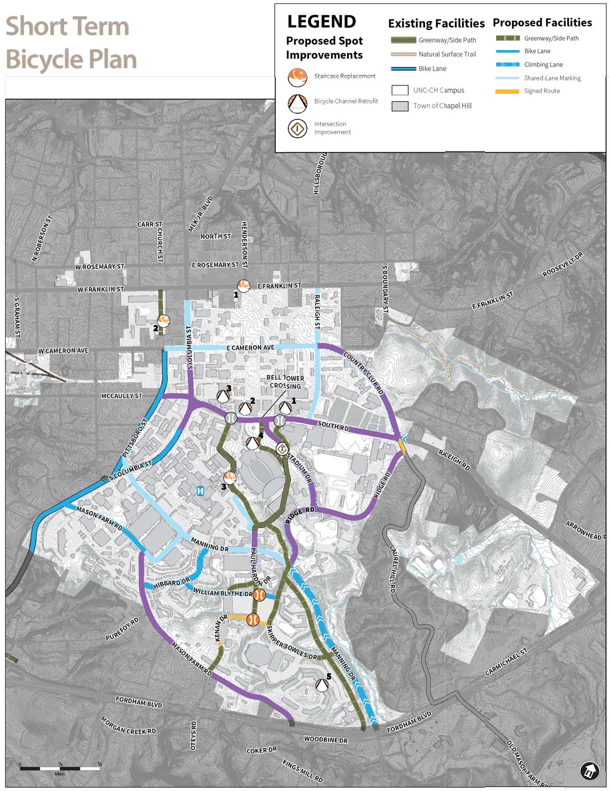
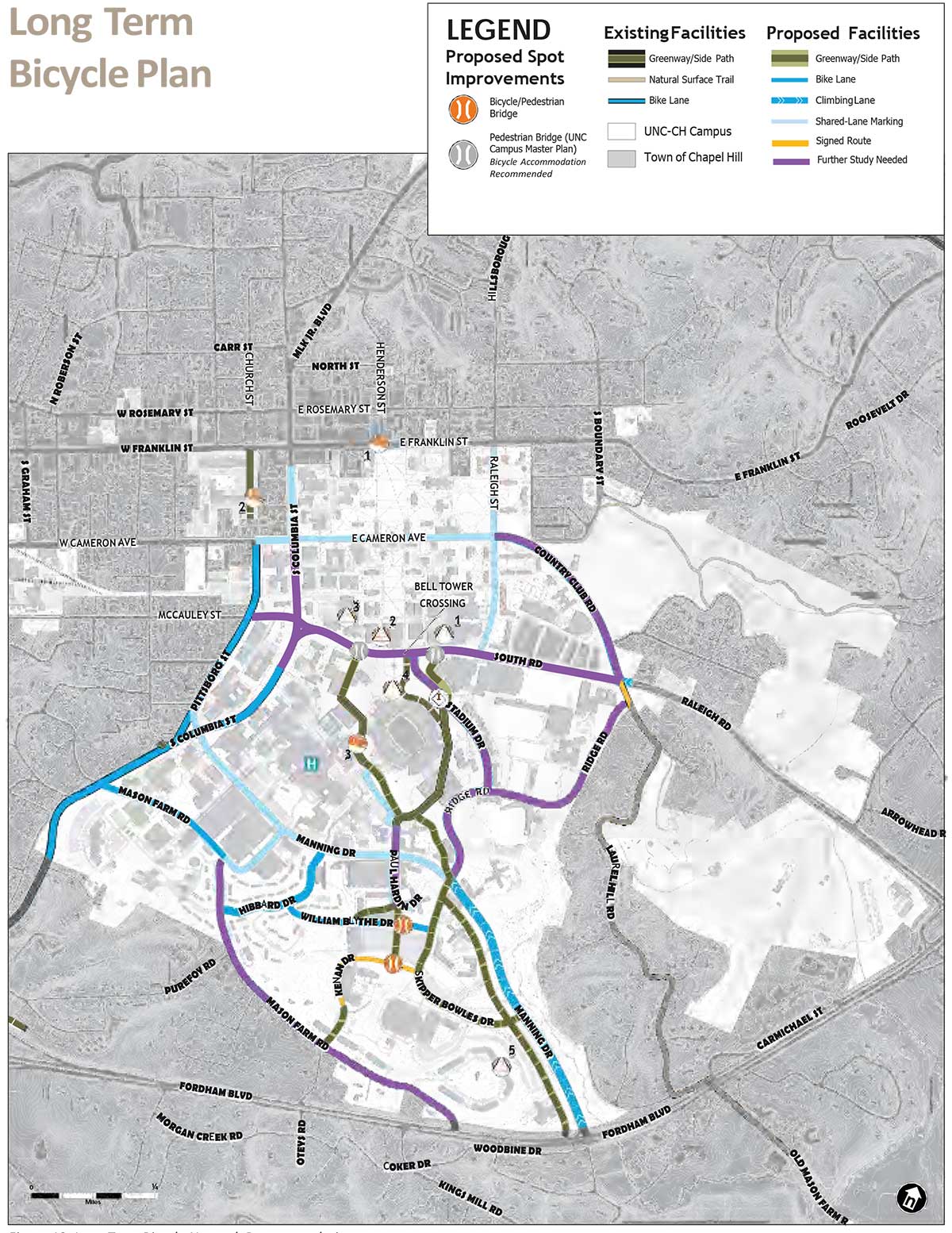
The long-term bicycle network was developed to guide the implementation of the campus master plan, which envisions new campus buildings, roadways and paths, as well as redevelopment of some existing buildings. The long-term recommendations are expected to be higher cost and will require reconstruction of roadways, installation of new paths and reconfiguration of parking. The locations for the improvements described below are depicted on the long-term map (see Figure 13) and in Appendix D with additional detail.

In the long term, Hibbard Drive and Mason Farm Road between Hibbard Drive and South Columbia Road are recommended to have bicycle lanes on both sides of the roadway to replace climbing lanes and shared lane treatments. Additional greenway or sidepath construction is also recommended to extend the internal pathway system and to provide a separated bicycle facility for motorized traffic. Examples include sidepaths along Raleigh Road, the lower part of Manning Drive and Skipper Bowles Drive.
The long-term bicycle network also identifies those segments which will require further analysis and coordination with partner agencies. Implementation of these projects will require collaboration between UNC-CH, the Town and in some cases the NCDOT. In many cases there are multiple options proposed for the bicycle accommodation. Additional information will be required to choose a preferred design treatment for some locations. The selection of a preferred treatment will require a careful evaluation of bicyclist needs and volumes, pedestrian volumes and traffic operations within the context of available space and budget to implement an improvement. The recommendation is to provide the highest quality bicycle facility to maximize separation from motorized traffic and pedestrian traffic. In many cases this is a cycle track as envisioned in the Town Plan or a sidepath or bicycle lane. As long-term projects are implemented, it will be equally important to consider facility type continuity along the route for the bicyclist. Appendix D provides additional information for each primary corridor critical to the long-term network, including an overview of existing conditions, purpose and need for improvements, long-term recommendation options, implementation challenges and potential cost.
Cycle Track
Cycle Track
Bike Lane
Bike Lane
Greenway
Greenway
To reduce bicyclists and pedestrian volumes at the Bell Tower crosswalk of South Road, this plan supports UNC-CH Master Plan recommendations to construct new non-motorized bridge crossings over South Road near Caudill Labs (Bell Tower Drive Bridge) and the Pit area (Pit Bridge). These new bridges have the potential to greatly improve north-south connectivity between south and north campus. These new connections will provide low stress and safe crossings and will reduce volumes at the Bell Tower crosswalk.
Intersection improvements will require additional study to determine the preferred improvement. A number of intersections were identified in this plan for improvement. Intersection improvements can enhance cyclist safety by eliminating or raising awareness of potential areas of conflict between motorists and cyclists, or between cyclists and pedestrians. The following intersection improvements are proposed for UNC-CH:

  • Provision of additional crossing time (walk time or green time) where no conflicting movements occur or time can be reallocated from a lower demand movement (example Cameron Avenue at South Columbia Street).
  • Provision of leading bicycle/pedestrian interval to reduce conflicts with turning traffic at signalized intersections (example Raleigh Street at Franklin). This would require bicycle signals at locations where the bicyclists are traveling in the roadway.
  • Reductions of curb radii to slow turning traffic (example Raleigh Road at South Road).
  • Widening of curb ramps on paths and sidewalks (example South Road at South Cameron Avenue).
  • Provision of actuated warning signs such as a Rapid Flashing Beacon (example Stadium Drive at East Kenan Connector Path).
  • Provision of automatic recall walk signals will result in the walk signal being triggered each cycle change of the traffic signal. This will ensure adequate crossing time is provided to pedestrians and bicyclists who operate on sidewalks and would not normally push the button (example Raleigh Street at Franklin Street).
  • Provision of pedestrian signals for all directions crosswalks should be located to ensure adequate information is provided to pedestrians and bicyclists who travel on sidewalks (example Fordham Boulevard at Manning Drive).
Future improvement plans for Kenan Memorial Stadium include the provision of a wide pedestrian concourse that completely encircles the stadium. Once complete, it will be open to bicycle and pedestrian travel except during major stadium events. This will result in the creation of a more level route between the Campus Health lawn and South Road along the west side of the Stadium similar to Rams Head Center.
The Town Plan recommended consideration of a cycle track network as an alternative type of bicycle accommodation for a number of roadways within the center of Town. These roadways included South Road, a portion of South Columbia Street and McCauley Street within the UNC-CH Campus. The cycle track network is proposed to separate bicyclists from pedestrians on roadways which have high volumes of pedestrians and bicyclists. The cycle track network proposed would complement the greenway network connecting the Town of Carrboro, UNC-CH, and Town of Chapel Hill business community, and major off-campus residences for UNC-CH students. A map of the proposed cycle track network is attached in Appendix D. Project descriptions provide additional details and considerations for a potential cycle track network for individual street segments as appropriate within the long-term recommendations description.
All streets, roads, paths, parking lots, intersections, and crossings are important for bicycle travel on campus. Locations not identified with specific action in this plan or included as a primary or secondary route should be considered for improvement as projects develop. Opportunities to provide improved bicycle infrastructure that is consistent with the policies and goals of this plan should be considered for all projects.
Long-Term Plan
Figure 13. Long-Term Bicycle Network Recommendations
Example Cycle Track
This is an example cycle track located in Amsterdam, Netherlands. It provides a high quality of service for pedestrians and bicyclists by separating the two user types. The Town Plan proposes a cycle track network as a long term alternative. A map of the Town proposed network is included in Appendix D.